
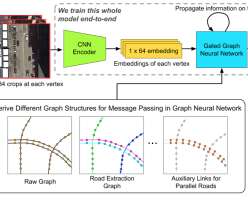
MIT, QCRI use AI to enrich digital maps to improve GPS navigation; RoadTagger
Green Car Congress
FEBRUARY 3, 2020
A model developed by Researchers at MIT and Qatar Computing Research Institute (QCRI) have developed a model that uses satellite imagery to tag road features in digital maps to help improve GPS navigation. Roads can be occluded by, for example, trees and buildings, making it a challenging task, however.


Let's personalize your content